Digital Mapping allows for the harmonious co-existance of time, space, and place. Simply put, digital mapping can be thought of as historical imagery that is representing or recreating change over time. Digital Mapping databases and softwares are particularly valuable for historians as it provides analysis and communication in both visual and spatial representations that shows the development of space over time. Digital mapping, when done correctly can effectively tell a narrative and/or convey meaning. In the exploration and review of an HGIS project from GeoSpatial Historian, I explored the city of London during WWII. In particular, this HGIS project focused the specific event of the London Blitz which took place from October 7th, 1940 to June 6th, 1941 as the Germans bombed Britain completely demolishing cities such as Bristol, Liverpool, and Manchester.
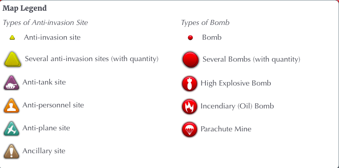
This project was far more multi-faceted than what originally meets the eye. Beginning with a rather simplistic map with a few data points in the forms of red icons either with the symbolic icon of a bomb or a number, the map quickly transforms.

Further exploration of the project reveals that there is a substantially concentrated cluster of data points.

Through exploring the reverse effects of this project and zooming in to focus on two or three data points, each datum contained recorded information about that particular bomb and its most proximal location. There is then an option to “read more”. At this point the project redirects viewers to another page with further details such as geographical coordinates, history of the area, and a photo archive of historic images related to that particular area. Digital historians have the opportunity to explore the following information available to them through this particular digital mapping project:
- Locations of bombs which fell:
- Between 7/10/1940 and 06/06/1941
- Week of 7th to 14th October 1940
- First 24 hours of the Blitz (7th September)
- Images from the Imperial War Museum Collections
- Memories from the BBC WW2 archive
- Location of different defences built to prevent a German Invasion

As explained above, digital mapping has the potential to tell a narrative. This particular project uses the visual and spatial components of HGIS to create a rather humanizing account of the London Blitz. Paring the visual representation of the city streets with the almost “address-like” locations of each of the bombs, it creates a tour-like experience and viewers feel connected to the city streets. Deeper than this, as viewers we have the opportunity to connect each point with a potential home that was a destroyed; and with that a potential family that may have been harmed or killed.

In additional to creating affect through narrative, this map is visually represented in a way that is aesthetic to the eye and easy to navigate. The instructions are quite clear and viewers have the freedom to explore the project at surface level, or delve into its breadth and depth to explore the potential history of each of the points; essentially the story behind each of the bombs. These factors contribute to its success.
This digital map is structured in a way that has so much potential to be an effective story map but falls just short of the opportunity by only visually implying the human narrative. While the map and data points are clear and simple, additional, and fairly tedious, effort must be used to collect information on these points. Being redirected away from the main map and only being able to focus on one singular point at a time can make it challenging for digital historians to analyze the possibility of emerging trends and/or patterns.
